Friday, November 28, 2014

Cemeteries of Munich

One of my goals is to visit the graves of famous physicists that happen to be buried in Munich. Usually because they lived in Munich (or died in Munich) and taught at the University of Munich (now called the Ludwig-Maximilians-Universität, LMU).

The first one I visited, two weeks ago, was the Alter Südfriedhof, just outside the old city walls near Sendlinger Tor. Buried there is Joseph Fraunhofer.


And also Georg Ohm.


Fraunhofer, of course, is one of the fathers of spectroscopy, and he was the first to discover the "Fraunhofer lines," absorption lines in the solar spectrum that allows us to determine the chemical makeup of the solar atmosphere.

Ohm is more famous. His law, Ohm's Law, is a description of the proportionality between current and voltage, and he was a professor at the Universität from 1852-1854. There is a nice statue of Ohm on Theresienstraße at the Technische Universität, TU.


Finally, last week, I visited the Waldfriedhof - the Forest Cemetery. Werner Heisenberg is buried there, the father of the uncertainty principle.


While he was never a professor here, he was a student. His advisor was another famous physicist, Arnold Sommerfeld, and Sommerfeld is buried in another Munich cemetery, the Nordfriedhof. I plan to visit that next, given that Ernst Mach (of Mach number fame) is buried in Nordfriedhof. Those pictures will be coming soon.

I have a special connection to Sommerfeld, as he is my academic great-grandfather. My PhD advisor, Burt Fried, did his graduate school at the University of Chicago under Gregor Wenzel. And Wenzel was also a student of Sommerfeld's. So I'm especially interested in Sommerfeld's grave.

Wednesday, November 26, 2014

Wank

My third trip to the Alps was to Garmisch-Partenkirchen, two towns that were combined into one by Hitler before the 1936 winter Olympics were held there. The towns are at about 720 m altitude, and nearby rise the sharp peaks of Zugspitze, Germany's highest mountain, on the border with Austria, and Alpspitze, a picturesque peak with a huge slab of an east face, sloping down at about 45 degrees.

I went with a former student of Hochschule München and some of his friends to 'climb' Wank, a smaller hill with no snow - currently the path up Zugspitze is closed because of snow. Here is a photo looking out over Garmisch from a few hundred meters up the trail. The Matterhorn-like peak in the background is Daniel, and is in Austria.


And here, looking slightly to the left of the previous photo, is the massif that contains Zugspitze (on the right) and Alpspitze (on the left).


And here they are together.


Wank is about 1800 m high, so the trail gained about 3500 feet in a very short distance. It was extremely steep. But I was with youngsters only half my age, so I had to keep up! After about 3 hours we made it to the top. Of course, since this is Bavaria, at the false summit just west of the peak, there was a large crucifix. And also, of course, since this is Bavaria, at the summit there was a restaurant and beer garden. Unfortunately, these were closed because of the season. They are open both in summer and winter, when the visitor population increases, but on a November weekend that wasn't supposed to be warm, but turned out to be about 55 degrees, they didn't think there would be enough hikers to support their sales.

Here is another view from the top, of a small town named Farchant.

Finally, after we hiked down, one of the young hikers had actually grown up in Garmisch, and took us to visit his grandmother. We were able to look around her house - which was 350 years old - and also have some homemade cookies - which were delicious. Then we went with his father, sister, and brother-in-law to have dinner at a local restaurant. On the advice of his father, who has been a chef for 35 years (a few in Washington, DC, and a few at the famous Hofbräuhaus) I ordered Wildgulash, which was a goulash with deer meat, a local specialty. Very good. Here's the restaurant.


Wednesday, November 19, 2014

Dachau

I went to Dachau on Monday.  It is very strange, because it is a nice little town who's name has such a bad connotation. To get there, you take the S2 train to Petershausen, although sometimes it doesn't go all the way to Petershausen, but only goes to Dachau. For these trains, it is somewhat uncomfortable boarding a train that says "Dachau." Of course, the people who live there probably wish that they weren't so infamous to the rest of the world.

Then, you take a bus to the KZ-Gedenkstätte (concentration camp memorial site). You can also walk the distance, following the path that the prisoners had to walk when they were discharged from the train, and there are signs along the way. In Dachau, as with many other German cities, there is a J-F Kennedy Platz, which is situated on the Sudetenlandstraße. (In Munich, there's a bridge over the Isar river named the JF Kennedybrücke.)

The memorial site itself is quite powerful. It was the first camp in Hitler's regime, started in 1933. It was intended for German politicians in order to solidify his control over Germany. Some things that I hadn't known before include the fact that for most of the war there were no Jews there. Hitler expressly did not want Jews in camps that were in Germany. This is why they went to camps in the occupied countries, like Auschwitz. Also, it's one of the few camps where some original building survive - although some have been reconstructed also. Many of the German camps were demolished and there is only a memorial site. In Bavaria, all school children are required to visit one of the camps, and many go to Dachau. Also, in Germany, all military officers are required to visit one of the camps.

The day I went it was very cold and gray. I suppose it gave me more of a feeling of what it was like, not that anything really could. I did think about the book by Louis Zamperini, and his description of the camps in Japan that he was in. The description of my guide was very similar.

Here are a few photos:


A "back alley" between buildings where - at the wall at the end - some firing squad executions took place.


The main square where "roll call" was taken twice a day. The prisoners had to stand for up to 3 hours as they were counted. It took so long because by the end of the war there were 40,000 prisoners.


The rows of foundations of the bunkhouses. The foundations are original, but the two bunkhouses at the far end are reproductions. The buildings had been demolished in the 1960s.


One of the poster in their extensive history exhibition. Translation: "Our last hope: Hitler." It is certainly true that, from what I've read, Hitler did seem like one who would lead Germany out of it's terrible economic crisis precipitated by the end of WWI and the world wide depression of the thirties.

Overall, quite an experience.

Sunday, November 16, 2014

S-bahn/Olympics

To get to work in the morning - and back in the evening, I take the S7 line of the S-bahn (Suburban or Surface). There is also the U-bahn (Underground) lines, which are more the typical subway. However, while the U-bahn is always underground, the S-bahn is mostly above ground in the suburbs, but underground in the city center. The U-bahn dates from the 1972 Olympics, and the S-bahn is about 20 years old.

Starting from a little south of my house, the stops are, heading north

Höllriegelskreuth
Pullack
Großhesselohe Isartalbahnhof
Solln
Siemenswerke
Mittersendling
Harras
Heimeranplatz
Donnersbergerbrücke
Hackerbrücke
Hauptbahnhof
Karlsplatz (Stachus)
Marienplatz
Isartor
Rosenheimerplatz
Ostbahnhof
...

I get on at Großhesslohe and off at Hauptbahnhof (central train station). Then I take the tram (either line 20, 21, or 22) north on Dachauerstrasse toward Hochschule München. The stops are

Hauptbahnhof Nord
Karlsstrasse
Stiglmeierplatz
Sandstrasse
Hochschule München (Lothstrasse)

I you keep going north on Dachauerstrasse, you will reach Olympiapark, the area where the Olympics were held: swim stadium, track and field stadium, and basically a very nice park. Here's a view of the swim stadium, where Mark Spitz won his 7 gold medals!


Monday, November 3, 2014

Hochfügen, Österreich

This past weekend I made it to Austria!! Friends of a friend - who are now my friends - invited me to join them on their weekend trip to their hütte (cabin) in the mountains. Until we were in the Alps, I did not realize that we were going to Austria. But now I've got another country under my belt. I don't think I'll make it to Vienna, Megan, but the Tirol region is close enough. Here was our route. What was really nice about it is that we climbed up the northern range of the Alps, and then dropped into the Inntal, which translates into 'Inn valley'. {This is just like the lakes, which are 'see', such as Königssee, where I went last weekend. Although, the English maps usually write 'Lake Königssee', which means 'Lake King's Lake.'  It's kind of like 'The La Brea Tar Pits' [more about that in my next post].} The Inntal is the valley of the Inn river, which flows into the Danube (or the Donau in Germany). There's a very nice map on the Wikipedia page. Of course, up river is the city of Innsbruck, which, since brücke means bridge, means 'Bridge over the Inn river.' It's amazing what a little language can teach you!! Here is a photo of a town on the Aachensee, which we passed just above the Inntal.


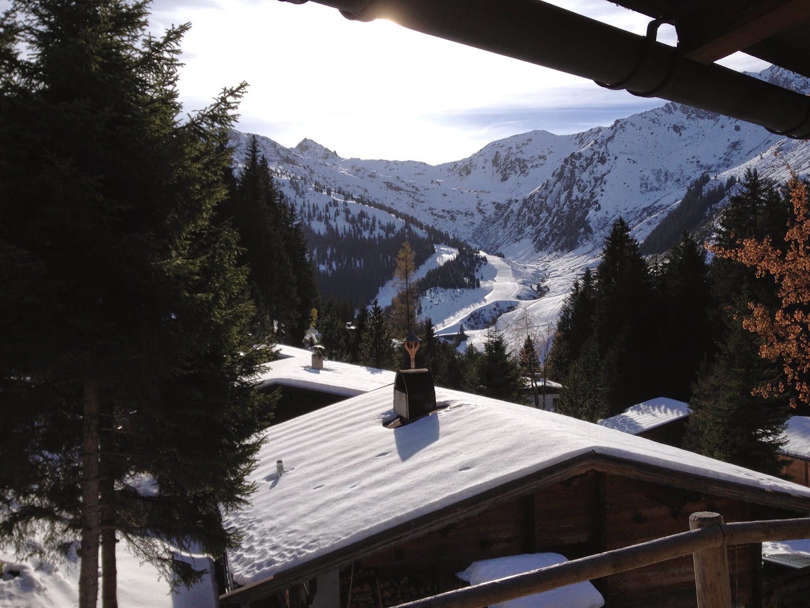
So then we crossed the Inntal and entered the Zillertal, which, as you might guess, is the 'Ziller valley.' The Ziller is a river that flows into the Inn. There is a lot of skiing up the Zillertal - really in the mountains above the Zillertal - and we headed up into the mountains at the town of Fügen. At the end of the road was the ski area, hotel, and cabins, called Hochfügen. And here's a photo from the front porch of the hütte, which overlooks the ski area.


It reminds me alot of the Big Bear/Lake Arrowhead area of LA. It's about a 2-3 hour drive from Munich, the cabins are at 1.600 m (about 5,000 feet), and the upper peaks that are visible are 1.000 m (3,000 ft) higher. The snow is at lower elevations here, I guess because it's further north. But it's very similar. And, of course, the first order of business was to decide which beer to drink!!


Here's the same view the next morning, when the sun was on the slopes. The temperature varied from about 2˚C - 10˚C. It was cold but pleasant because of the sun.


At the local tavern, I posed with a young friend next to a sign that must be wrong? The circumference of the earth is close to 40.000 km. Even though the Earth is an oblate spheroid, with an equatorial radius of 6378 km and a polar radius of 6357 km, this makes any circumference within 100 km of 40.000. This sign implies a polar circumference of 41.390 km, which is definitely too large. The equatorial circumference is 40.074 km, and the polar distance must be less that that. I didn't notice this until I was posting this photo. I don't know if I'll make it back there, but if I do, I'll let the proprietor know!